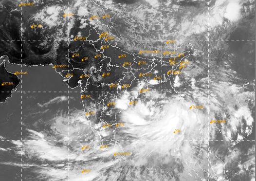
The Well Marked Low Pressure Area on the South Bay of Bengal has concentrated into a depression and lay centered on Friday and is very likely to continue to move northeastwards and intensify further into a cyclonic storm over eastcentral Bay of Bengal by 25th May morning, the India Meteorological Department (IMD) has said today. After intensifying into a severe cyclonic storm by 25th night, cyclone Remal is likely to cross Bangladesh and adjoining West Bengal coasts between Sagar Island and Khepupara around 26th May midnight as a severe cyclonic storm, IMD added.
The gale wind speed is expected to reach 100-110 gusting to 120 kmph over North Bay of Bengal from morning and 110-120 kmph gusting to 120 kmph from evening of 26th May.
Nagaland, Manipur, Mizoram & Tripura is likely to get isolated heavy to very heavy with extremely heavy falls (>204.4 mm) on 27th May and heavy to very heavy rainfall (115.5-204.4 mm) on 26th & 28th May, 2024. pic.twitter.com/XcpPvDOQty
— India Meteorological Department (@Indiametdept) May 24, 2024
IMD has issued warnings for heavy rain and squally wind for West Bengal, Coastal Odisha and the States in North East India. Orange Alerts have been issued for the states of Assam, Meghalaya, Arunachal Pradesh, Nagaland, Mizoram, Manipur and Tripura for 27th and 28th May 2024. For Mizoram, Nagaland, Manipur and Tripura, the “Be Prepared” warning is for 26th, 27th and 28th May.
Squally wind speed reaching 50-60 kmph gusting to 70 kmph is likely over Mizoram and Tripura and 40-50 kmph gusting to 60 kmph is likely over South Assam and Meghalaya on 27th May, the weather centre informed.
Oman has named the 2024’s first pre-monsoon cyclone ‘REMAL’, which means ‘SAND’ in Arabic.