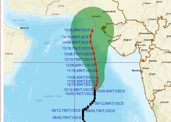
The very severe cyclonic storm ‘Biparjoy’ is very likely to intensify into an extremely severe cyclonic storm during the next 12 hours but may not hit Gujarat as per the current forecast, an IMD official said on Saturday.
The cyclone is likely to pass at a distance of 200-300 km from the Porbandar coast but will bring thunderstorms and strong wind in the western state in the next five days.
In its latest forecast, the IMD said the very severe cyclonic storm ‘Biparjoy’ is very likely to intensify further into an extremely severe cyclonic storm during the next 12 hours and move north-northeastwards gradually during the next 24 hours, before moving north-north-westward during the subsequent three days.
“The cyclonic storm currently lays 600 km from Porbandar. As it approaches, the port signal warning will be changed accordingly. For now, the cyclone is likely to pass from a distance of 200-300 km from Porbandar and 200 km from Nalia (Kutch). As far as the current forecast is concerned, it is not likely to hit Gujarat,” said the director of the Ahmedabad IMD (India Meteorological Department) centre, Manorama Mohanty.
Fishermen have been warned against venturing into the Arabian Sea during the next five days and all fishing activities have been suspended, she told reporters.
“The cyclone is moving in the near northerly direction which continues for now. It is likely to change its movement to northeastward in the next 24 hours. Thereafter, the movement of the cyclone will be north-northwestward,” Mohanty said.
Gujarat will witness thunderstorm activity during the next five days with wind speed remaining high especially in the Saurashtra-Kutch region, she said.
VSCS BIPARJOY at 1430IST near latitude 16.9N and longitude 67.4E, about 700 km WNW of Goa, 620 km WSW of Mumbai, 580 km SSW of Porbandar and 890 km S of Karachi. To intensify further and move NNE-wards gradually during next 24 hours. @WMO @moesgoi @DDNewslive @airnewsalerts pic.twitter.com/H1zWDFhhU6
— India Meteorological Department (@Indiametdept) June 10, 2023
As per the IMD’s latest forecast, ‘Biparjoy’ lay centred at 1130 am over east central Arabian sea about 700 km west-northwest of Goa, 620 km west-southwest of Mumbai, 590 km south-southwest of Porbandar and 900 km south of Karachi.
“It is very likely to intensify further and move north-northeastwards gradually during the next 24 hours. Then it would move gradually north-northwestwards during the subsequent three days,” the IMD said.
“During the next two days, the Saurashtra-Kutch region will witness a wind speed of up to 30-40 kmph. Thereafter, the region may witness wind speed of up to 30-50 kmph gusting to 50 kmph, especially in coastal areas during June 13-15,” Mohanty said.
She said wind speed inside the sea will gradually increase from Sunday ranging from 35-45 kmph to 50 kmph of Saturday to 40-50 kmph gusting to 55 kmph, then to 50-60 kmph on June 12 and from 50-60 kmph gusting to 70 kmph on Jun 13-14.
“As far as the current forecast is concerned, the cyclone is not likely to hit Gujarat in the next five days,” Mohanty added.
The cyclone will bring a comparatively strong wind, especially in coastal districts such as Porbandar and Kutch, and Jamnagar gusting to 60 kmph and increasing to 75 kmph, she said.
Authorities have dispatched teams of the National Disaster Response Force (NDRF) to the districts of Porbandar, Gir Somnath and Valsad.
The Indian Coast Guard has commenced an outreach to advise the fishing community, seafarers and stakeholders of Gujarat, Daman and Diu to take requisite precautions and safety measures.
The ICG units are communicating regular advisories to vessels at sea through ships, aircraft & RADAR stations.


